When we were planning the excavation of the enclosure at Yorkley, we noticed that nearby there was an abandoned settlement called Tomlin so we decided to investigate. Through historic documents and photographing the site we discovered more about the site and its owners the James’ family.
Read on to discover more!
Initial research
We first noticed Tomlin when we were looking at some historic maps of the area. Ordnance Survey (OS) maps from 1878 and 1901 showed three roofed buildings at Tomlin, surrounded by a series of enclosures and a number of tracks and paths. Two of the enclosures were illustrated as orchards and a well was also marked to the north of the settlement. Beyond this, the entire settlement was surrounded by woodland.
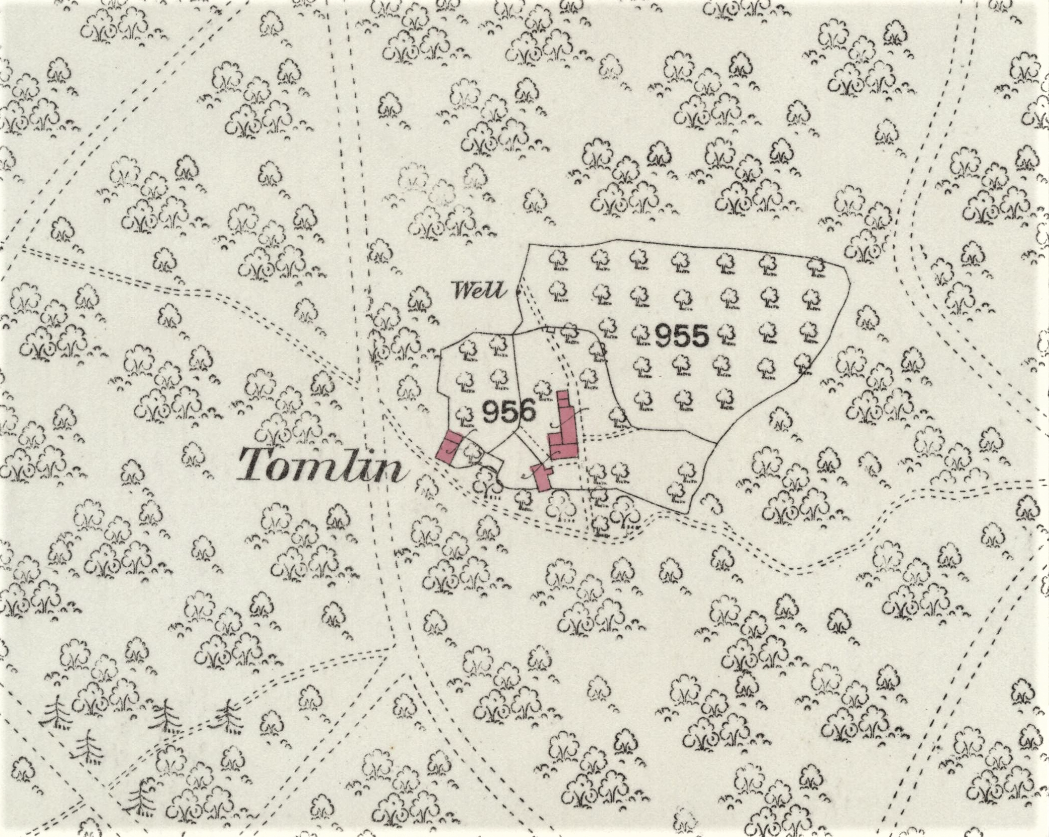
Reproduced with the permission of the National Library of Scotland
The next documents we checked were the Victoria County History (VCH) for the area, and the Lloyd George Survey of Land Values (undertaken in 1910). The VCH simply said that ‘there were at least three cottages in the early 1770s’ but only a single abandoned house by 1958 . However, the Lloyd George Survey of Land Values recorded two plots at Tomlin both owned and occupied by Hartley James. So, for the first time, we had the name of someone who lived at Tomlin. The Land Values survey recorded a house and garden with a gross value of £9 and land measuring just over one and half acres valued at £2 14s . We had also identified that the 1920 OS map showed all three buildings as unroofed, indicating the settlement was abandoned between 1910 and 1920.
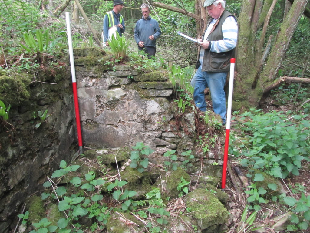
Site survey
During our excavations at Yorkley we made a number of trips to Tomlin. Our Initial survey revealed that the three buildings illustrated on the OS maps still survived as a series of very overgrown walls. We found that the settlement appeared to have been constructed on two roughly rectangular shaped terraces, located on the side of an east facing slope. The topography means that features such as walls and small banks are not easily identifiable on the lidar survey
The western building was situated on the upper terrace, while the southern and eastern buildings was located on the lower terrace. We think the western building, which is the largest of the structures at Tomlin, was probably the cottage where the family lived together while the two smaller building were probably for storage and agricultural use.
The James family
During these investigations further documentary research of census returns and parish records was carried out. This identified that Hartley James was born in Newland Parish on 22nd March 1829 and was the son of James James (born c.1796) and Maria Stephens (born c.1800), who married on the 7th August 1826. In 1841 the family were living together at Tomlin and Hartley was one of seven children, he had an older sister (Caroline-14) and five younger siblings (Alvan-10, Rhoda-7, James-5, Timothy-3 and Amos-2 ?weeks).
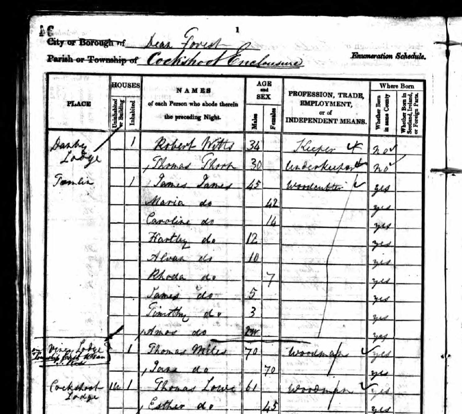
The 1851 census records that James and Maria had had another child called Emmily (now 6), although Caroline (now 24) had left Tomlin. Hartley’s occupation was recorded as wood cutter. A second couple, John Fisher (53) and his wife Ann (60), were also recorded living at Tomlin in 1851, although they have not been traced on other returns and it is unclear how long they lived at Tomlin.
By 1861 both Hartley and his father were recorded as wood cutters and only Hartley and his two youngest siblings (Amos and Emmily) were still at Tomlin, living with their parents. James James died on 27th September 1865, and left £100 in his will.
In 1871 Hartley’s mother Maria (now 71) was recorded as the head of the family with only Hartley (now 41) and his 23 year old cousin Emma ?Hablam, a domestic servant, living with her.
In 1881 Hartley was recorded as the head of the family and now married to Elizabeth (born c.1835); later census returns indicate they married around 1875. Hartley and Elizabeth were recorded at ‘Tomlin House’ in 1891, and by 1901 Hartley was retired and their niece, Hilda Morris (born c.1892), was living with them. The 1911 census records the three still living together at Tomlin in a four roomed dwelling and that Hilda was working at home as a dressmaker. Hartley died at the age of 84 on 25th March 1913. He left £471 in his will to various beneficiaries including Elizabeth and Hilda.
In the nearby Church of All Saints, Viney Hill, there is a glass window depicting the prophet Moses. This window is dedicated to Mr and Mrs Hartley James of Tomlin, a lasting testament to both Hartley and Elizabeth, and Tomlin itself.
Further research
We think that Tomlin was probably established in the 18th century when encroachment into the Royal Forest by squatters was common. The Crown fought against this activity with periodic mass evictions but in 1838 they granted freehold status to older encroachments and offered to sell any encroachments less than 50 years old to the occupants. We know that the James’ were a family of woodcutters who worked for the Crown during the 19th century but did their ancestors originally squat at Tomlin, claiming part of the Royal Forest for themselves, or were they there legally and perhaps even granted the land to build their cottage and orchard? We hope that further research as well as archaeological excavation at Tomlin can help answer this question and tell us when Tomlin was originally established…
loading map - please wait...